
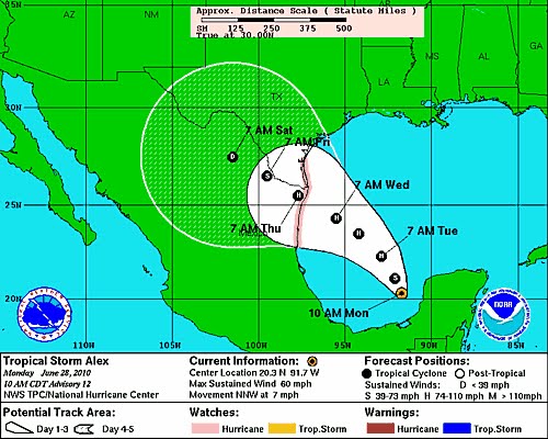
Tropical storm Alex, currently located in the Bay of Campeche, is expected to gather strength slowly over the next 24 hrs as it moves to the west-northwest. Over the weekend the projected track of the storm, first moved toward Central Mexico, then at 04:00 this morning began moving northward. As can be seen in the picture above, hurricane tracking has a historic 250-300 mile error range after 48 hrs. With the current expected landfall strength of Category 2, and the large diameter of the system, any land fall over the Rio Grande Valley, could mean significant rain fall with the possibility of flash flooding in low lying areas across South Texas and possibly as far north as the Hill Country. As with all related tropical systems, we will have a better idea of the impact area(s) and potential outcomes to Central Texas and other areas of the state within the next 36-48 hrs. This system should be watched closely. If you aren't prepared already, better get started now.
We are not "looking down the barrel" at this point, but we are certainly "standing on the wrong end of the shooting range".
Be aware. Be informed. Be prepared.
Riverwalker


2 comments:
I linked this post over on my blog RW. Loved your quote at the end and added it too (with proper credit of course). Don't worry though, nobody reads mine yet ;)
I got my inner tubes all aired up, and the surfboards waxed! Heh heh, looks like we'll just have a little high water and a soggy couple days. But I'm keeping my eyes peeled just the same...
Post a Comment