Showing posts with label Storm Alerts. Show all posts

Thursday, January 6, 2011

Weather Update - Possible Arctic Blast in South Central Texas

The weather models have been pointing toward a possible extreme cold weather outbreak next week across much of the country; this includes the South Central Texas area. Everything has to be just right to get a major arctic blast into our area, and the weather forecast models are showing things coming together for just such an event.

This possible cold outbreak starts with a strong cold front pushing through the area sometime on
Monday of next week. Arctic air over Canada will then continue to surge south into the southern plains through Tuesday and Wednesday of next week with a possibility of it lasting even longer towards the end of next week. The forecast weather pattern points toward the coldest air of the season with very hard freezes possible next week. The forecast models keep this arctic air over the plains area for the entire week, with reinforcing shots of cold air coming from western Canada, right down the lee side of the Rockies and into Texas. We could be looking at a lengthy cold outbreak with possible record low temperatures and record low maximum temperatures. Record lows across South Central Texas next week are generally predicted to be in the low to mid teens. The currently forecast weather patterns indicate some record temperatures could occur.

With that said, many things can happen between now and next week. The forecast models could change, the cold air could head a bit further east, etc. While it is way to early to tell you particulars of exactly how cold or how long this arctic blast could last, you should make your preparations ahead of time and increase your situational awareness. Please start following the weather forecasts very closely and logging onto weather websites frequently (www.srh.noaa.gov/ewx) .

If this is what could be a true arctic blast, history has shown us that weather forecasting models will underestimate the strength of this cold air. If you have winter emergency action plans, now is the time to get them out and start to review them in preparation of for a possible need to be actively ready for this arctic blast.

This needs to be watched closely.

Be aware. Be informed Be prepared.

Riverwalker

Thursday, July 1, 2010

Alex Update - Rain Impact Areas


There has not been a whole lot of change from the update posted yesterday. Rainfall continues to be our main impact from Hurricane Alex. Hurricane Alex will likely make landfall tonight over northeast Mexico south of Brownsville. Like we saw yesterday, the counterclockwise circulation of Alex is bringing large amounts of moisture onto the coast and pushing it into South Central Texas.

Daytime heating will likely trigger storms again late this morning into the afternoon and evening hours. As was seen near the San Antonio airport Monday, and in Austin yesterday afternoon, some of the storms will produce torrential rainfall in a short amount of time...these can be rates of 2 inches per hour or more. These rainfall rates and the tropical nature of the atmosphere have increased the potential for flash flooding over the area. For this reason...the National Weather Service has issued a Flash Flood Watch for all of South Central Texas through 7 pm on Thursday.
Bands of showers and thunderstorms wi ll produce 2-4 inches of rain over the next several days with isolated totals of 6+ inches possible, mainly over southern areas. Just in the past two days, they have had cars stranded in water and even some rescues had to be made.

Please remember...Turn Around Dont Drown.

Winds will only be an issue in the vicinity of these showers and thunderstorms. Typically with a strong thunderstorm it is not uncommon to get wind gusts of 40-50 mph. We do not expect any sustained tropical storm force winds as the circulation of Alex will remain too far south.
Any wind damage that does occur will be very isolated and limited to strong thunderstorms.

Because the circulation of Alex is forecast to hit south of Brownsville, the tornado threat will likely remain over Deep South Texas. We also can't rule out the possible threat of a tornado, but the main threat area will be well south of San Antonio.

The unstable and moist atmosphere will stick around for several days...even after Alex makes landfall tonight. For this reason...scattered showers and thunderstorms will remain in the forecast over the holiday weekend. Rain chances of 30-40 percent should mean however that activity will be scattered and most scheduled events can go on with possible brief interruptions from the weather. Areas along the Rio Grande from Del Rio southward will have to watch Alex closely as there is a chance for significant rains over the mountains of Mexico. In the past, these type of events have led to flood events along the Rio Grande.

Please check the latest information on forecasts, watches, and warnings by going to the website at www.srh.noaa.gov/ewx A picture depicting the rain and flooding threats that are possible is included.

Be aware. Be informed. Be prepared.

Riverwalker

Wednesday, June 30, 2010

Alex Update - Predicted Flood Areas and Rainfall Rates


Alex continues to slowly strengthen and is making a path toward South Texas and extreme northern Mexico. Ahead of this tropical system, easterly and northeasterly flow to its north is pulling in large amounts of moisture from the northern Gulf. This moisture, combined with a weakness aloft and daytime heating will continue to trigger scattered showers and thunderstorms over the next 24 hours ahead of Alex. This activity has the potential to create locally heavy rain with some isolated flash flooding. This may become a major concern. Some of these storms may have rainfall rates of 1 to 2 inches per hour. This is enough rain to cause problems due to flooding in low lying areas as well as more urban areas.


As Alex makes landfall to our south by late Wednesday, even more moisture will push onshore and make its way into South Central Texas. It appears that the main threat from this system will be locally heavy rain and possible flooding. Here is the latest graphic showing the rainfall estimates that are forecast by meteorologists. There are 3 to 4 inches of rain being forecast. There are some isolated totals of 6 inches or more that are generally being forecast for southern areas of South Central Texas. As the center of Alex is forecast to be well south of the area, we do not expect to have sustained tropical storm force winds. Breezy conditions ranging from 15 to 30 mph may occur generally south of a line from Del Rio to San Antonio to Cuero. The strongest winds (20-30 mph) will most likely occur Wednesday night with the possibility of some slightly higher gusts. These forecast wind speeds can also be found on the graphic. However, with any thunderstorm, there is always a threat of wind gusts of 30 to 40 mph, with some reaching speeds as high as 50 mph or more.

Any sort of tornado threat appears to be small. If we do get a threat for small tropical tornadoes, this threat would likely occur Wednesday night or Thursday as rain bands from Alex rotate west and northwest into the area. This would mainly impact southern areas of South Central Texas.

If the remnants of Alex head west as forecast, we will continue to see a threat of heavy rainfall through Friday. The threat may in fact then turn into a river flood threat for areas along the
Rio Grande River. This will most likely be in areas near Eagle Pass and Del Rio. The second picture shows the possibility of this threat as well.

Overall, the threat for South Central Texas appears to be mainly heavy rain. Some southern areas may get isolated rainfall totals of 6 inches or more over the next several days.

Stay informed by going to the National Weather Service webpage www.srh.noaa.gov/ewx and continue to monitor the latest forecasts and tracks of Alex as it approaches.

We are not "looking down the barrel" at this point, but we may be "standing too close to the target.”

Be aware. Be informed. Be prepared.

Riverwalker

Tuesday, June 29, 2010

Update on Alex


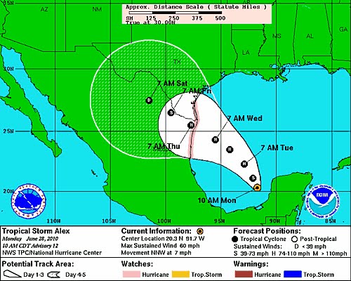
Tropical storm Alex, currently located in the Bay of Campeche, is expected to gather strength slowly over the next 24 hrs as it moves to the west-northwest. Over the weekend the projected track of the storm, first moved toward Central Mexico, then at 04:00 this morning began moving northward. As can be seen in the picture above, hurricane tracking has a historic 250-300 mile error range after 48 hrs. With the current expected landfall strength of Category 2, and the large diameter of the system, any land fall over the Rio Grande Valley, could mean significant rain fall with the possibility of flash flooding in low lying areas across South Texas and possibly as far north as the Hill Country. As with all related tropical systems, we will have a better idea of the impact area(s) and potential outcomes to Central Texas and other areas of the state within the next 36-48 hrs. This system should be watched closely. If you aren't prepared already, better get started now.

We are not "looking down the barrel" at this point, but we are certainly "standing on the wrong end of the shooting range".

Be aware. Be informed. Be prepared.

Riverwalker

Wednesday, July 8, 2009

Texas Hurricane Season Preparedness 2009

People living along the texas Gulf Coast should begin their preparedness for the hurricane season of 2009. You should have an evacuation plan ready, prepare an emergency kit in advance and learn the evacuation routes for your area.

Gulf Coast residents who have specialized health care needs, including those who are disabled or have other limiting medical problems can register in advance with the State of Texas for special assistance by calling 2-1-1. This must be done in advance of any storm that happens to pop up in the Gulf. The State will make special arrangements when you register to make sure you have the proper medical care available to you in case of an evacuation. If you don't have family or friends that can assist you in being able to meet special medical care needs, the State will provide the necessary assitance for you. You must register in advance of any storm to get this benefit!

Similar assistance is also available for those who lack the necessary transportation to evacuate in the case of a hurricane, you only need to dial 2-1-1 in advance and register for emergency transportation.

You can also dial 2-1-1 and get evacuation zone information for your area of the state.

For more information about these emergency services you can visit the Governor's Division of Emergency Management website:


Be aware. Be informed. Be prepared.

Riverwalker

Friday, September 12, 2008

Hurricane Ike - Update - Port and Refinery Closures and Emergency Procedures

Information about fuel supplies in Texas has been obtained and is being posted here and on Stealth Survival for the benefit of people wanting more information prior to Hurricane Ike's arrival on the Texas Gulf Coast.

Here is that information:

Update, September 11, 2008 – 2:00 p.m.

Storm Update:

As of 10:00 a.m. CDT Thursday, Hurricane Ike was about 470 miles east-southeast of Galveston, Texas. Ike is traveling west-northwestward at 10 mph with maximum sustained winds of 100 mph. Ike is a very large Category 2 hurricane. Hurricane-force winds extend 115 miles outward from Ike's center. Tropical storm-force winds extend outward up to 275 miles.

The circulation of Ike is so large that it is already causing water levels to rise 1-3 feet across the entire Gulf Coast from South Florida to Texas.

The best estimate right now is for landfall somewhere between Matagorda Bay and Galveston, Texas. Nonetheless, a devastating storm surge is expected for more than 100 miles east of landfall. One should not focus on an exact landfall location at this time, and all interests along the western Gulf Coast should monitor the progress of Ike closely.

Ike will remain a major hurricane when making landfall along the Texas coast during the early morning hours Saturday. There is some chance for Ike to become a Category 4. hurricane;

Operational Update:

No wide-spread outages have been reported. Historically, we do experience spot outages due to the increased demand. We are focusing on regional evacuation outages and as we can.

Other reports:

The overall fuel system is stressed with increased demand.

DEMAND:

In the Houston area, retailers reporting retail demands that are 4-5X higher than normal but not abnormal for this type of situation.

FUEL RESPONSE:

The industry continues to obtain, position, and load fuel into the Texas regions likely to be impacted by Hurricane Ike.

REFINERIES:

Refineries are evaluating their safety considerations and shut-down processes.

Seven of nine Houston-area refineries representing roughly 1,985 million barrels of refining capacity have confirmed that they are shutting down ahead of Hurricane Ike.

Another refinery in Corpus Christi has shut down, taking an additional 288,000 barrels per day out of the fuel supply. Valero’s refinery in Port Arthur is operating at reduced levels.

TERMINALS:

It is likely that once terminals experience sustained tropical winds (39 mph), the racks will shut down loading activities until it is safe again. Tropical Storm winds are to be expected in the Houston/Pasadena area sometime on Friday morning. After Hurricane Ike passes through and all assets are operational the Truck Rack will reopen and all customers/carriers will be contacted. Racks in San Antonio, Dallas/Fort Worth, and Houston are increasing supplies in readiness.

RETAIL STATIONS:

Grade outages reported at some stations. Demand is intense in some locations and this changes as refueling occurs and newevacuation takes place.

Dynamic Messaging:

Since Ike has entered the Gulf, TXDOT is now running messages on their dynamic message boards on the Gulf coast that a hurricaneis in the Gulf and to fuel vehicles.

Evacuations:

The following counties have issued Mandatory Evacuations: Galveston, Chambers, Jefferson, and Orange.

Partial Evacuations: Southern Harris and Matagorda.

The following counties have issued voluntary evacuations: Nueces, Victoria, Brazoria, Jackson, and San Patrico.

Waivers:

TXDOT issued the waiver for overweight trucks and hours of service. (See TxOGA’s website).

TCEQ: TCEQ will exercise its enforcement discretion in advance of Hurricane Ike's projected landfall for temporary vehicle fueling facilities (Stage II Vapor Recovery Requirements) to allow for fueling of vehicles from facilities other than service stations. The length of time for this enforcement discretion is through the duration of this event. Please know that TCEQ is supportive of this proposal, to allow the flexibility needed to prepare for and respond to the catastrophic threat Texas faces from Hurricane Ike.

TCEQ is granting a 1 week extension for the Title V deviation report.

The TCEQ will extend its enforcement discretion in advance of Hurricane Ike's projected landfall to the counties to be potential impacted, and from today (September 11, 2008) through the "duration of the event." This will include:

Ongoing physical opacity monitoring and leak detection and repair (LDAR) requirements, including daily and weekly audio, visual and olfactory requirements, component monitoring and inspections, carbon canister monitoring, container monitoring, initial repair attempts, final repairs, and follow-up monitoring;

Periodic monitoring of cooling tower systems;
Periodic sampling of storm water outfalls;
Periodic groundwater monitoring and inspections pursuant to agreed orders or compliance plans;
Inspections of hazardous and solid waste storage areas;
Continuous Emission Monitoring (CEMs) requirements due to the potential loss of CEMs prior to equipment being brought down;
State and federal NSPS, NESHAP and MACT requirements regarding flare operations and monitoring due to potential loss of pilot flame and inability to monitor;
State and federal NSPS and MACT requirements for floating roof tanks, including the potential for landing tank roofs on their legs;
Recordkeeping and reporting obligations related to the above; and
Other recordkeeping and reporting obligations that would otherwise be due during this period.

TCEQ will exercise its enforcement discretion in advance of Hurricane Ike's projected landfall to industry that is within an area covered by a mandatory evacuation order. The requested length of time for this enforcement discretion is from the date of the mandatory evacuation order until, through the duration of the event. This will include:

State and federal NSPS, NESHAP and MACT requirements regarding control devices (vapor recovery units, vapor combustor units, and flares), including permit terms and conditions.

Truck Staging:

San Antonio has offered Wolff Stadium as a staging area for fuel trucks and chemical haulers to wait out the storm. Please contact Debbie Hastings at 512-424-2208 (Fuel desk) for more details.

Ports:

The U.S. Coast Guard ordered area the Port of Houston Port to begin closing to ship traffic today over concerns that Hurricane Ike would produce rough seas.

Port Freeport, about 65 miles south of Houston in a mandatory evacuation zone for Brazoria County, shut down early Wednesday afternoon.

Port Lavaca no ships are coming into the port.

The Port of Galveston is closed.

Recovery and Re-entry:

Employers report that they are activating their response teams are preparing for recovery including the pre-positioning of generators. We are working with TCEQ to obtain waivers specific to staging temporary fuel tanks for these generators.The re-entry letter prepared for Hurricane Gustav will be applicable for Hurricane Ike. (The letter and motor carrier waiver are available on TxOGA’s website.) As a reminder:

Please keep a list of persons to whom your company distributes this letter. This list should be available should the state request confirmation of individual names.

In addition to this letter from the state, your re-entry employees/contractors will need a letter from your corporate office authorizing them as critical personnel.

Re-entry employees will need photo identification like a driver's license or employee identification.

If personnel have TWIC cards or local credentials, please ensure that they have those as well. The more information that they have available to demonstrate their critical role in the re-entry process, the smoother it should go.

Be aware. Be informed. Be prepared.

Riverwalker